
A technical analysis of China’s satellite constellation and its impact on the competitive landscape of precision positioning
The global navigation satellite system landscape is experiencing its most significant transformation since GPS first achieved full operational capability in 1995. With more than 70 satellites currently visible and approximately 120 satellites expected once all four major systems are fully deployed, the era of American GPS dominance is giving way to a multi-constellation reality where China’s BeiDou Navigation Satellite System (BDS) has emerged as a formidable competitor, fundamentally altering the strategic and technical dynamics of precision positioning.
As aerospace engineers and technology strategists grapple with this shifting paradigm, understanding the technical capabilities, architectural innovations, and competitive positioning of modern GNSS systems has become critical for making informed decisions about navigation infrastructure, autonomous systems, and location-based services.
Technical Performance: Beyond Simple Accuracy Metrics
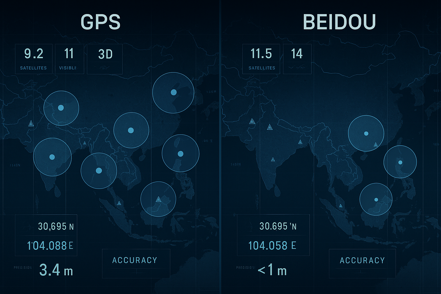
The question of whether BeiDou has “surpassed” GPS requires careful examination of specific performance parameters across different operational contexts. Current evaluation results indicate that BDS-only precise point positioning achieves 0.16 m (95%) horizontal accuracy and 0.22 m (95%) vertical accuracy, with convergence times under 20 minutes. These specifications represent significant technical achievement, particularly when compared to standard GPS civilian service.
However, accuracy comparisons reveal a more nuanced picture. BeiDou provides greater accuracy (less than 1 meter) compared to GPS (less than 4.9 meters) for standard positioning services, though both systems achieve positioning accuracy within 10 meters for open service, with timing accuracy within 50 nanoseconds and velocity accuracy within 0.2 meters per second. The apparent discrepancy in reported accuracy figures reflects different measurement methodologies and service tiers rather than fundamental technological limitations.
BeiDou can achieve positioning accuracy within one meter for public use and centimeter-level precision for military applications, while standard GPS typically provides accuracy within 3 meters. Yet this comparison overlooks GPS’s enhanced precision services and military capabilities, which remain classified but are known to achieve comparable accuracy levels.
Constellation Architecture: Innovation Through Hybrid Design
BeiDou’s most significant technological advancement lies not in individual satellite capabilities but in its constellation architecture. The BeiDou constellation operates more satellites than GPS or any other system and maintains more than ten times the monitoring stations in other countries compared to GPS deployment. This infrastructure advantage translates into measurable performance benefits in specific regions.
BeiDou’s hybrid orbit system offers superior regional coverage in Asia, particularly over China, while GPS and Galileo generally provide better coverage and accuracy in most other regions. The system employs a sophisticated combination of Medium Earth Orbit (MEO), Geostationary Earth Orbit (GEO), and Inclined Geosynchronous Satellite Orbit (IGSO) satellites, enabling enhanced signal availability and geometric diversity in the Asia-Pacific region.
This architectural approach represents a strategic design philosophy that prioritizes regional excellence while maintaining global capability. Unlike GPS’s purely MEO constellation, BeiDou’s hybrid design provides additional satellites visible from any given location within its primary service area, reducing the geometric dilution of precision and improving positioning reliability.
Competitive Landscape: Multi-Constellation Reality
The contemporary GNSS environment has evolved beyond bilateral competition to encompass multiple sophisticated systems. Galileo launched its High Accuracy Service (HAS) in 2023, targeting position accuracy of 20 cm horizontally and 40 cm vertically, with the EU claiming it as the most accurate service globally. However, GPS remains more resilient, and the Galileo system remains incomplete.
GLONASS currently achieves accuracy of 2.8 meters, with positioning ground stations under construction in Russia, Antarctica, Brazil, and Indonesia to improve its ground segment. The proliferation of these systems creates both opportunities and challenges for precision applications.
Modern receivers increasingly leverage multi-constellation capabilities, utilizing signals from GPS, GLONASS, Galileo, and BeiDou simultaneously. Adding multiple GNSS constellations into receiver design provides better reliability, particularly in challenging terrain, though BeiDou delivers more satellites, better availability, and enhanced features depending on geographic location.
Strategic and Economic Implications
The geopolitical dimensions of GNSS competition extend far beyond technical specifications. By 2015, fifteen years after BeiDou’s initial launch, the system was generating $31.5 billion annually for major companies including China Aerospace Science and Industry Corporation, AutoNavi, and Norinco. This economic impact demonstrates how satellite navigation systems function as critical infrastructure supporting entire industrial ecosystems.
Fifty years after GPS was designed and approved by the U.S. Department of Defense, the system faces risk of losing its status as the world’s gold-standard location service, according to industry analysis. This shift reflects not just technical advancement but changing geopolitical realities where nations seek independence from foreign-controlled critical infrastructure.
The strategic implications extend to developing nations, where BeiDou’s superior monitoring station network deployment results in significantly better accuracy in many places, particularly in the developing world. This infrastructure advantage positions China as a preferred partner for nations building location-based service capabilities.
Technical Challenges and Limitations
Despite significant achievements, BeiDou faces technical challenges that constrain its global competitive position. The operational PPP-B2b service of BDS-3 achieves decimeter-level positioning accuracy within 14 minutes but has drawbacks in regional coverage and longer convergence times compared with international counterparts such as CLAS of QZSS and HAS of Galileo.
Interoperability remains another critical consideration. While modern receivers can process signals from multiple constellations, devices relying on multi-constellation GNSS consume more power as they require additional energy to seek connections with various satellite signals using different frequency bands. This power consumption penalty affects battery-operated devices and mobile applications.
The complexity of multi-constellation processing also introduces new failure modes and requires sophisticated algorithms to resolve conflicts between different timing references and coordinate systems. These technical challenges require careful engineering to realize the theoretical benefits of multiple GNSS availability.
Future Trajectory: Integration and Innovation
The GNSS landscape continues evolving toward deeper integration with emerging technologies. Building upon its PNT services, BDS actively offers diversified specialized services in 2024, including augmentation services for autonomous vehicles, precision agriculture, and industrial IoT applications.
The integration of GNSS with 5G networks, artificial intelligence, and edge computing creates new possibilities for location-aware applications while introducing new technical requirements. Ultra-reliable low-latency communications (URLLC) applications demand positioning accuracy and availability guarantees that exceed current civilian service specifications.
As autonomous systems proliferate across transportation, agriculture, and industrial sectors, the reliability and resilience of positioning services become paramount. This trend favors multi-constellation approaches that provide redundancy and improved availability, regardless of which individual system offers superior peak performance.
Conclusion: Redefining Navigation Excellence
Rather than representing a simple displacement of GPS dominance, BeiDou’s emergence reflects the maturation of satellite navigation technology and the strategic recognition that critical infrastructure requires redundancy and competition. The system’s technical achievements, particularly in regional accuracy and constellation design, demonstrate significant engineering capability while highlighting the continued importance of geographic context in GNSS performance evaluation.
For technology leaders and system architects, the key insight lies not in identifying a single “superior” system but in understanding how different GNSS constellations complement each other across various applications and operational environments. The future of precision positioning increasingly depends on intelligent integration of multiple satellite navigation systems rather than reliance on any single constellation, regardless of its individual technical merits.
As the global navigation satellite ecosystem continues evolving, success will be measured not by replacing existing systems but by creating more robust, reliable, and capable positioning infrastructure that serves an increasingly connected and autonomous world. In this context, BeiDou represents not just China’s achievement but a catalyst for innovation across the entire GNSS community.